NASA Unveils Stunning New Views from Artemis II’s Close Lunar Flyby
Artemis II performed a historic swing around the moon, coming within 4,067 miles of the lunar surface and releasing a set of striking photographs captured during the maneuver.
Artemis II’s Lunar Flyby: A Precise Maneuver
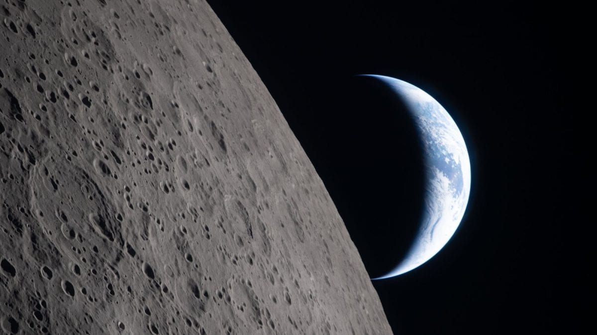
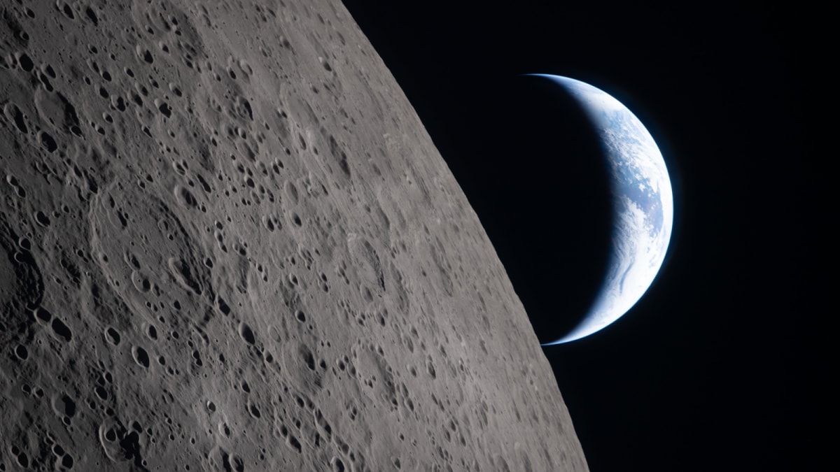
During the most recent deep‑space flight, Artemis II executed a carefully planned trajectory that allowed the spacecraft to glide past the moon at a distance of just 4,067 miles. This proximity represented a deliberate decision to collect visual data while preserving the safety envelope established for crewed missions. The distance of 4,067 miles placed Artemis II well within the range at which high‑definition imaging equipment can resolve surface features, opening a window for the scientific community to review fresh visual material from a perspective rarely attainable.
The navigation team relied on a series of pre‑programmed burns and real‑time adjustments to maintain the exact path required for the close approach. By holding a steady line of sight on the moon throughout the encounter, Artemis II’s onboard cameras remained active, continuously gathering photons reflected off the lunar terrain. The result is a collection of images that capture the moon’s rugged topography illuminated by the Sun’s glare, contrasted against the blackness of space surrounding it.
What the New Images Reveal
The photographs released by NASA showcase the moon’s surface in a manner that emphasizes the stark interplay of light and shadow. Craters, ridges, and the subtle undulations of the lunar highlands appear with a clarity that highlights the natural texture of the regolith. Though the images were taken from a distance measured in thousands of miles, the resolution is sufficient for observers to discern major geological formations without the need for close‑up proximity.
Each frame captures a different angle of the moon, reflecting the gradual rotation of the celestial body against the background of stars. The changing illumination across the series illustrates how sunlight sweeps over the lunar landscape, casting elongated shadows that accentuate the depth of craters and the steepness of mountain rims. The visual narrative constructed by the image set offers a dynamic portrait of the moon, moving beyond static, single‑point snapshots to a fluid representation of its appearance during the flyby.
Beyond the aesthetic value, the images serve as a technical benchmark for future missions. By comparing the visual data obtained during this close flyby with earlier pictures taken from more distant orbits, engineers can assess the performance of the camera systems under varying lighting conditions and distances. The consistency of color balance, contrast levels, and sharpness across the series validates the robustness of the imaging hardware employed on Artemis II.
Context Within the Artemis Program
Artemis II’s successful navigation around the moon marks a significant milestone in the broader effort to return humans to the lunar surface. The close approach, at a measured distance of 4,067 miles, demonstrates that NASA’s current generation of spacecraft can safely operate within a tight corridor around the moon while still fulfilling scientific objectives. This accomplishment builds confidence for upcoming missions that will travel farther, land, and eventually establish a sustained presence on the lunar terrain.
The decision to capture and disseminate high‑resolution images was intentional, reflecting NASA’s commitment to transparency and public engagement. By providing the world with a fresh visual perspective, the agency invites both the scientific community and the general public to share in the excitement of a historic event. The images act as a bridge, connecting viewers on Earth with the reality of a journey that once only existed in imagination.
While the primary goal of Artemis II’s flyby centered on testing the spacecraft’s performance during a lunar pass, the secondary outcome of obtaining visual data adds a layer of value that extends beyond engineering. The astronomical community can incorporate the images into educational materials, outreach programs, and comparative studies that examine the moon’s appearance from multiple mission profiles.
Technical Aspects of the Imaging Process
The camera suite aboard Artemis II was calibrated before launch to operate across a range of exposure settings, ensuring that the sensors could adapt to the bright glare of reflected sunlight and the deep darkness of space. During the flyby, the system automatically adjusted shutter speed and aperture based on real‑time analysis of incoming light levels, preserving detail in both the illuminated portions of the moon and the surrounding star‑filled background.
Data transmission played a crucial role in making the images available shortly after capture. Artemis II relayed the raw image files to ground stations using a high‑gain antenna, which then routed the data through NASA’s communication network for processing. The processing pipeline involved noise reduction, color correction, and alignment of multiple frames to produce a seamless visual series. Throughout this workflow, the original scientific integrity of the images was maintained, allowing analysts to trust that the visual representation mirrors the actual scene observed during the flyby.
Because the images were taken from a distance of 4,067 miles, the optical system required a specific focal length to achieve the desired field of view. The balance between magnification and breadth of perspective ensured that the photographs captured both the immediate vicinity of the lunar horizon and a broader swath of the surrounding space, emphasizing the vastness of the lunar environment.
Public Reception and Educational Impact
Since the release of the new visual material, the response from educators, students, and space enthusiasts has been overwhelmingly positive. Teachers have incorporated the images into lesson plans that explore lunar geology, orbital mechanics, and the engineering challenges of crewed spaceflight. The vivid depiction of the moon’s surface, taken from an unprecedented angle, provides a tangible reference point for discussions about cratering processes, volcanic history, and the evolution of the lunar environment.
Social media platforms have amplified the reach of the images, with users sharing the photographs alongside commentary that highlights the achievement of Artemis II’s close approach. By circulating the visual content widely, NASA fosters a sense of collective ownership over humanity’s next great leap beyond Earth’s atmosphere. The images act as a catalyst for curiosity, inspiring younger generations to consider careers in science, technology, engineering, and mathematics.
Beyond classrooms and online forums, the photographs have found their way into museum exhibits and public display screens at science centers. Curators have arranged the images alongside historical artifacts from earlier lunar missions, drawing direct comparisons that underline the progress made over decades of exploration. This juxtaposition reinforces the narrative that Artemis II represents both a continuation and an evolution of the legacy established by prior missions.
Future Prospects and Ongoing Analysis
The visual dataset gathered by Artemis II will continue to be examined by researchers seeking to extract additional insight. Advanced image‑analysis algorithms can be applied to the photographs to map surface features with higher precision, supporting future landing site assessments. Although the distance of 4,067 miles limits the granularity achievable compared to a surface‑level survey, the images nonetheless contribute valuable context for planning subsequent missions that will travel closer or make direct contact with the moon.
NASA’s ongoing commitment to sharing mission data ensures that the scientific community can leverage the imagery in conjunction with other observational platforms, such as orbital satellites and Earth‑based telescopes. By correlating the perspectives captured by Artemis II with those from other sources, a more comprehensive three‑dimensional model of the lunar surface can be refined, enhancing navigation and hazard avoidance strategies for upcoming landers.
As Artemis II’s flight path continues beyond the close flyby, mission controllers will monitor the spacecraft’s performance during the remaining phases, applying lessons learned from this segment to the development of later Artemis missions. The success of the imaging operation underscores the importance of integrating scientific payloads with crewed flight objectives, a practice that will shape the design of future missions targeting not only the moon but also deeper destinations in the solar system.