How an AI Traced Ancestral Land Records in India
Zahid Khan, an Amazon executive based in Bengaluru, started a whole conversation online recently. It blew up a bit. He shared how he used Anthropic’s AI assistant, Claude , to actually trace and map his ancestral land. All of it happened in rural Uttar Pradesh.
He posted it on LinkedIn, and it just caught the attention of tech folks and regular social media users. It got a lot of traction.
Khan explained the setup. The land itself was in Mohammadpur village. It’s the kind of place you inherit things from, passed down through generations. Great-grandfather, then grandfather, then his late father, and finally, him.
But here’s the kicker. Despite inheriting the property, Khan admitted he barely knew where the actual plots were. He’d only visited the village a handful of times in his life.
He wrote something kind of rambling, actually. “I used Claude Cowork to find my ancestral land in rural India!” That was the hook.
The real difficulty wasn’t just finding the place. It was the paperwork. The land records, even though they were digitized, were scattered across various government portals. And they were written in this really formal Hindi. The kind of Hindi that makes legal documents feel like ancient scripture.
That’s what he meant.
He said recommendations from friends pushed him to try using Claude’s "computer use" feature. The AI handled most of the heavy lifting, apparently. It helped him pinpoint about twenty-five plots connected to his family.
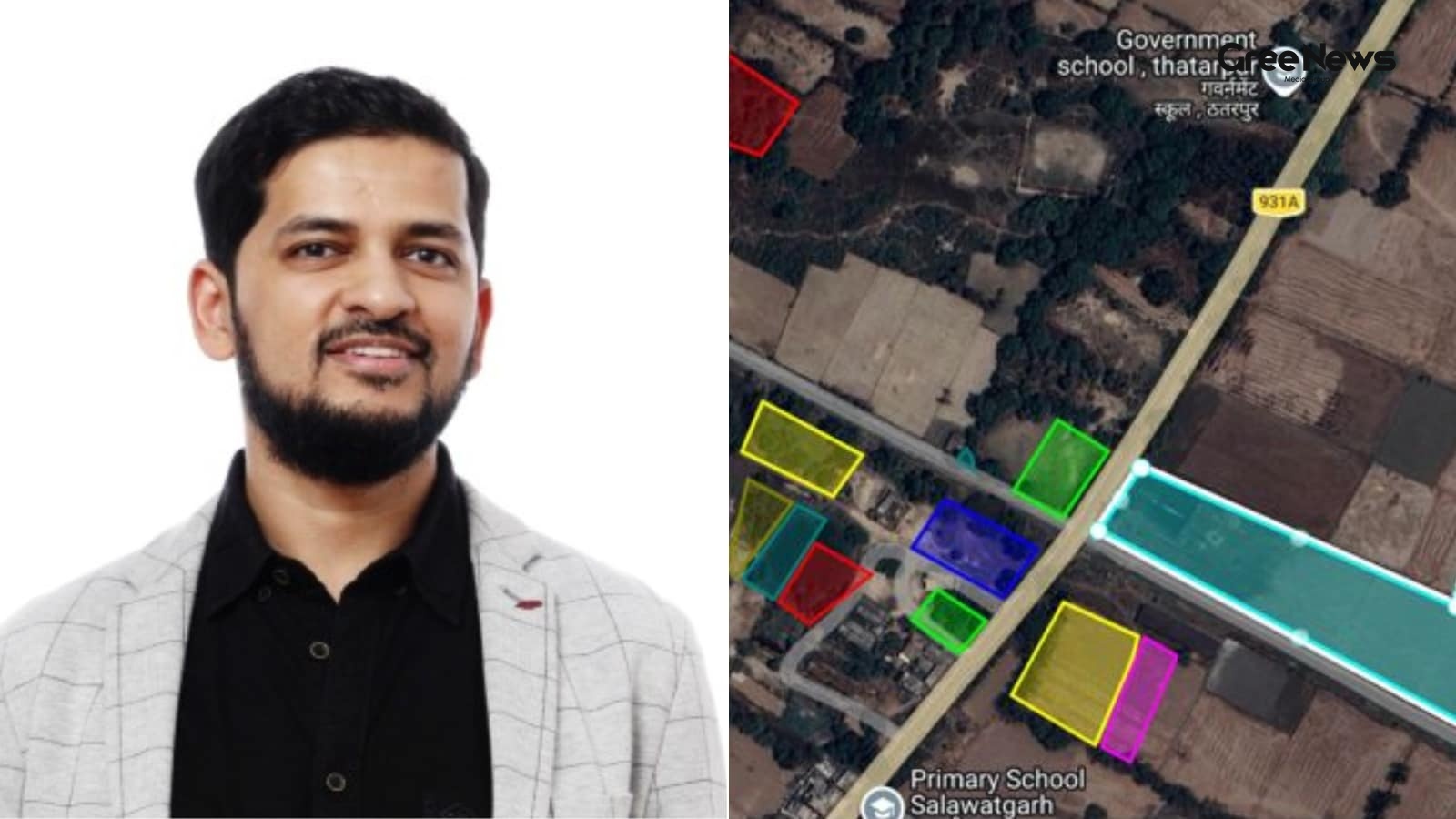
How did it actually work? The AI started by searching official land records. He typed his father’s name in Hindi onto an on-screen keyboard. The AI then spotted plots where his father was listed as an owner or co-owner. It pulled out the Gata Sankhya—the plot numbers—from the government mapping portals.
But the AI didn’t stop there. It noticed something else. The coordinates weren’t standard latitude and longitude. They were in Universal Transverse Mercator, or UTM format. Claude just switched gears. It converted those coordinates. Then it generated a KML file. All the land polygons, neatly packaged up. And then it uploaded it to Google My Maps. A navigable map. Showing the exact boundaries.
The executive joked that this whole ambitious project eventually pushed him out of Claude’s free tier. He ended up needing the paid Pro and Max plans just to keep going.
The online reaction was wild. People were fascinated. Some were just amused.
“This is crazy and awesome,” one user commented. They asked how much hand-holding or course correction Khan actually needed.
Then you get the practical stuff. Another user jumped in. “This is one of the few real use cases I’ve seen for AI. It’s super encouraging. This should be turned into an agent for the Government Registrar of Property website.”
And naturally, some people just wanted to jump in. “I need to do this for my ancestral land too! I’ll use these exact steps. Thanks for sharing!”
Of course, there were the jokes too. Some people just focused on the money side. “Rich man problem 😅 using Gen AI to find owned properties!”
Another comment touched on the absurdity of the effort versus the reward. “For twenty thousand rupees a month (Claude Max), someone in the village would’ve mapped the land, settled disputes, and arranged chai too 😄”
It just sparked a much bigger discussion. It really opened up conversations about what generative AI can actually do when you throw it at India’s incredibly complicated government record systems. It made you think about the practical side of this technology, not just the hype.
Written by Gree News Team — Senior Editorial Board
Gree News Team covers international news and global affairs at Gree News. Our collective of senior editors is dedicated to providing independent, accurate, and responsible journalism for a global audience.
More from Top News
View All
The Reality of Tech Salaries and Social Media Hype
A screenshot surfaced online recently. It was this image that really caught fire across social media. Someone posted it claiming to show a massive salary credit for a fresher who just landed a spot at Microsoft. It immediately started sparking arguments. People were debating the reality of these sta
Jun 10, 2026 by Gree News Team

Accountability and Ethics: The Fallout of a Workplace Controversy
That guy from Gurugram who blew up online over a joke he made on Pranit More’s show is now facing real consequences. Himanshu Jangra was the one involved. He showed up on that episode and brought up some stuff about a date. Apparently, he said he asked for "sexual favours" in return for dinner back
Jun 9, 2026 by Gree News Team

Federal Judiciary Strikes Down Controversial H-1B Visa Fee
Donald Trump really lashed out at the federal judiciary after some Massachusetts district judge struck down his administration’s controversial $100,000 fee on new H-1B visas. It was a big deal. The ruling immediately caught the attention of immigration advocates and the Indian diaspora community. Ma
Jun 9, 2026 by Gree News Team

The Intersection of Petty Scams, Systemic Failure, and National Disillusionment
A Delhi man started this whole thing online, you know? Just rambling about what happens on the streets. It wasn't some official police report or anything formal. it was just him talking, trying to explain how these things happen, how people are getting ripped off in the shadows of everyday life. He
Jun 9, 2026 by Gree News Team
Latest Headlines

Political Speculation and Internal Turmoil within the TMC
Fresh visuals surfaced of Sushmita Dev meeting Assam Chief Minister Himanta Biswa Sarma. That kind of thing just kicks the speculation into high gear about her next move. It’s all about her potential entry into the BJP, right? This happened right after she stepped down from Rajya Sabha and walked ou
Jun 10, 2026 by Gree News Team

FIFA World Cup 2026: Structure, Geography, and the Official Match Ball
The FIFA World Cup 2026 is really starting to feel imminent now. It’s heading toward North America the USA, Mexico, and Canada are slated to host this massive global spectacle. People are talking about it constantly. It’s not just a standard tournament anymore. This time around, they’re throwing way
Jun 10, 2026 by Gree News Team

Lionel Messi and Argentina's World Cup Journey in Group J
Argentina’s taking on Group J in this new setup USA, Mexico, and Canada it feels like more than just football now. It’s about that farewell, isn't it? Lionel Messi is chasing something special right now, playing out this final chapter with the Albiceleste against Algeria, Austria, and Jordan. There’
Jun 10, 2026 by Gree News Team

Federal Judge Bars Nitrogen Gas Execution in Alabama
A federal judge just slammed the door shut on Alabama’s plan to use nitrogen gas for executing Jeffery Lee. Permanently barred it, ruling the method violated basic constitutional rights about cruel and unusual punishment. This decision dropped like a stone. It came just one day after an appeals cour
Jun 10, 2026 by Gree News Team

Kerala Board Plus One Results 2026 Announcement and Checking Methods
The Kerala Board Plus One results for 2026 are finally coming today, June 10th. That’s when the Directorate of Higher Secondary Education will officially announce everything. Students who took the DHSE Kerala Class 11 exams in 2026 can start checking their scores now. You have a few places to look,
Jun 10, 2026 by Gree News Team
Threats and Intimidation Against Former Judge Justice Gautam Patel
Chief Justice Surya Kant stepped in on the matter involving threats and intimidation aimed at former Bombay High Court judge Justice Gautam Patel. This happened while he was visiting the UK, raising the issue with India’s High Commissioner there. It came out of a report by The Times of India. The wh
Jun 10, 2026 by Gree News Team

Intersection of Art, Politics, and Public Morality at Film Screening
The buzz around the screening for ‘Bharat Bhhagya Viddhaata’ was definitely something special that Tuesday evening in Delhi. It wasn't just about watching a movie; it felt like a convergence a mix of film fans, some political heavyweights, and a surprising amount of high-level government presence. P
Jun 10, 2026 by Gree News Team

The Political Feud: Shivakumar vs. Kumaraswamy and the Vokkaliga Rivalry
A meeting that hasn't even happened is already sparking political sparring. Karnataka Chief Minister DK Shivakumar and Union Minister HD Kumaraswamy. It just underlines how bitter one of the state’s longest-running rivalries still is. Shivakumar was doing some outreach, a carefully choreographed exe
Jun 10, 2026 by Gree News Team

Protest and Political Standoff in Mexico City Before the World Cup
A protest choked off an avenue leading right to Mexico City’s Azteca Stadium for hours on Tuesday. It was just days before that massive World Cup opening match. As football fans started flooding in, all those co-hosts the US, Canada, and Mexico you see the real mess happening back home. Thousands of
Jun 10, 2026 by Gree News Team

The Global Nuclear Arms Race: Spending, Capabilities, and Future Risks
Nearly eight decades since Hiroshima and Nagasaki. And the world’s nuclear powers aren't slowing down. They keep spending more, modernizing faster, and experts are watching them move weapons out of storage and into potential use. It’s a real arms race happening right now. The nine states that hold n
Jun 10, 2026 by Gree News Team

The Chaos of Cinema: Volume, Competition, and the Shifting Market
The Friday arrived packed. June 12th. It wasn't just another day; it was a collision of cinema. Nine films, all hitting the screens at once. *Main Vaapas Aaunga*, Imtiaz Ali’s directorial effort. Then you had Kangana Ranaut’s *Bharat Bhhagya Vidhaata*. And the horror mixed in Vikram Bhatt’s *Haunted
Jun 10, 2026 by Gree News Team

Stock Market Updates: June 10th Performance and Sector Analysis
Stock market updates today, June 10th. Everything turned sour in late trading Wednesday. Domestic equity markets basically gave up all those gains they managed to hold during the day. Heavy selling hit midcap, smallcap stocks, plus metals, realty, and financial names dragging the main indices into n
Jun 10, 2026 by Gree News Team

Iran Football Team Travel and World Cup Arrangements
Iran’s football team is heading to Los Angeles, apparently. They announced Tuesday that they'll be flying there the day before their first group-stage game against New Zealand. It feels like a lot happening all at once. But where exactly will they be staying? They won't actually be in L.A. for long.
Jun 10, 2026 by Gree News Team

The Impact of Gen AI on Job Applications and Hiring Strategies
When you start looking for a job, everyone builds this whole structure: the résumé, that killer cover letter, tailoring it perfectly. The whole point was always that application could make you jump out from the crowd of hundreds of applicants. But honestly? Recruiters are starting to think that play
Jun 10, 2026 by Gree News Team

Narendra Modi's Milestone: India's Longest-Serving Prime Minister
Narendra Modi just hit a huge milestone. India’s longest-serving elected Prime Minister. Forty-three hundred ninety-nine days in office now. That beats Nehru's record, which was the first one. Former Vice President Venkaiah Naidu spoke about it. He praised the leadership and everything Modi has done
Jun 10, 2026 by Gree News Team